The content of this page has been verified by the Belbex Research team – CoStar Group
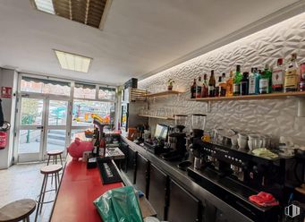
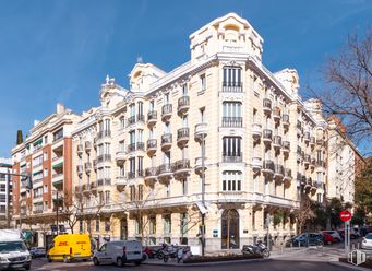
Magnificent commercial premises on street floor located on Paseo de la Habana just 100 meters from Santiago Bernabeu Stadium. We can find in an immediate environment textile operators such as Zara Adolfo Dominguez Oysho Massimo Dutti and catering operators such as Rodilla Vips and Tattaglia.
Last updated 3 months ago
Building info
Total Floor: 9Construction year: 1968
Amenities
Heating
Elevator
Natural lighting
Fire detection system
Public Transportation
Location map
Map loading...
Rent history
Floor
Use
m2
Date
2
Office
215
Oct. 2022
2
Office
130
Jul. 2020
Ground
Retail
171
Feb. 2016
Note: This table contains the listings added and the listings that were modified according to their type, use, m2 or price
Transport
Bus
Line
Distance
Pº Habana-Pza.Sagrados Corazones
14
43 m
Concha Espina-Pza.Sagrados Corazones
14, 150
126 m
Av.Concha Espina-Pza.S.Corazones
43, 120
150 m
Concha Espina-Pza.Lima
43, 120
243 m
Underground
Line
Distance
Santiago Bernabéu
10
398 m
Concha Espina
9
754 m
República Argentina
6
770 m
Nuevos Ministerios
6, 8, 10
796 m
Commuter train
Line
Distance
Nuevos Ministerios
C1, C2, C7, C8, C8a, C8b, C10
671 m
Chamartín
C1, C2, C7, C8, C8a, C8b, C10
2 km
Transport Node
Distance
Intercambiador de Nuevos Ministerios
671 m
Estación de Madrid-Chamartín
2 km
Estación de Atocha Renfe
5 km
Aeropuerto Adolfo Suárez-Madrid Barajas
10 km
Taxi
Stop
Distance
Plaza de los Sagrados Corazones, 1
05.05 a
86 m
BiciMAD
Distance
Paseo de la Habana, 42
157 m
Points of interest
Commercial areas
Distance
C.C. La Esquina del Bernabéu
144 m
C.C. Moda Shopping
463 m
Mercado Municipal de Chamartín
1 km
Mercado Municipal de Prosperidad
1 km
Hotels
Distance
Hotel Holiday Inn Madrid-Bernabeu ****
601 m
Hotel AC Aitana ****
617 m
Hotel Miguel Ángel *****
2 km
Public Administration
Distance
Embajada de la República Federal de Nigeria
151 m
Embajada de la República de Guinea
271 m
Delegación Central de Grandes Contribuyentes Agencia Tributaria
706 m
Junta Municipal de Distrito. Chamartín
986 m
Ayuntamiento de Madrid
4 km
Health
Distance
Centro de Salud Segre
122 m
Hospital San Rafael
459 m
Protection and security
Distance
Compañía de Ministerio de Defensa
658 m
Policía Municipal (OAC) Chamartín
987 m
Comisaría General Extranjería y Fronteras, Oficina de Extranjero - Madrid
1 km
Parque de Bomberos de Madrid Nº 1. Chamberí
2 km
Other points of interest
Distance
Farmacia Paseo de la Habana 52, Madrid
7 m
Farmacia Avenida de Concha Espina 10, Madrid
111 m
Gasolinera Calle Serrano, 197
405 m
Parking mixto. Avda. Brasil
809 m
Parking público. Calle Príncipe de Vergara (Auditorio)
Chamartín District is located to the north of Madrid, covering an area of 919.57 hectares and includes the quarters: El Viso, Prosperidad, Ciudad Jardín, Hispanoamérica, Nueva España and Castilla. This district was originally a small village near Madrid Called Chamartín de la Rosa. It borders to the north with Fuencarral - El Pardo, to the east with Ciudad Lineal, to the south with Salamanca District, to the southeast with Chamberí and to the west with Tetuán. One of the main mid and long distance and high speed train stations is located here, namely Chamartín Station, also serving the local railway.