The content of this page has been verified by the Belbex Research team – CoStar Group
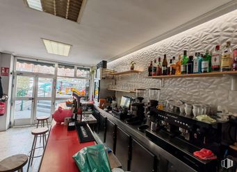
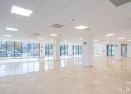
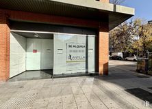
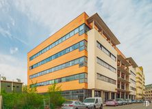
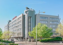
Fabulous commercial space with an area of 35 m2 and with many possibilities for reform.
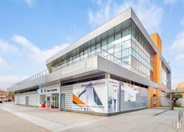
The place is located on Paseo de Extremadura, on a street with a lot of pedestrian and vehicle traffic, a stone's throw from several bus stops and the Puerta del Ángel metro station (line 6).
Two months' deposit is required.
Spaces
Floor
Use
m2
€/mo
€/m2/mo
Space layout
Availability
Ground
Retail
35
800
22.86
Open Plan
Available now
Last updated 2 weeks ago
Building info
Total Floor: 5Construction year: 1948
Amenities
High ceilings
On the street
Showcase
Bus stop
Public Transportation
Natural Light - Good
Metro station
Location map
Map loading...
Contact
Transport
Bus
Line
Distance
Pº Extremadura-Pta.Del Angel
31, 33, 36, 39, 65, N18, N19
91 m
Caramuel-Antonio Zamora
138
209 m
Doña Berenguela-Caramuel
138
233 m
Pº Extremadura-Guadarrama
31, 33, 36, 39, 65, N18, N19
254 m
Underground
Line
Distance
Puerta del Angel
6
226 m
Lago
10
601 m
Alto de Extremadura
6
800 m
Interurban bus
Line
Distance
Madrid - Santa Úrsula - Antonio Zamora
500
109 m
Madrid - Guadarrama - Grandeza Española
500
229 m
Madrid - Pº Jesuitas - Pza. Cerro Bermejo
500
277 m
Commuter train
Line
Distance
Príncipe Pío
C1, C7, C10
1 km
Pirámides
C1, C7, C10
2 km
Laguna
C5
2 km
Sol
C3, C4
2 km
Transport Node
Distance
Intercambiador de Principe Pío
1 km
Estación de Atocha Renfe
3 km
Estación de Madrid-Chamartín
8 km
Aeropuerto Adolfo Suárez-Madrid Barajas
14 km
Taxi
Stop
Distance
Calle de Antillon, 2
10.04
108 m
Points of interest
Commercial areas
Distance
Mercado Municipal de Tirso de Molina
290 m
Mercado Municipal de Alto Extremadura
739 m
C.C. Barrio Art Decó
762 m
C.C. Principe Pio
1 km
Hotels
Distance
Hotel NH Ribera del Manzanares ****
999 m
Hotel City House Florida Norte by Faranda ****
1 km
Hotel Barceló Torre de Madrid *****
2 km
Public Administration
Distance
Junta Municipal de Distrito. Centro
2 km
Primera Instancia
2 km
Primera Instancia
2 km
Ayuntamiento de Madrid
3 km
Administración de la Agencia Tributaria Montalbán
3 km
Health
Distance
Centro de Salud Caramuel
439 m
C.E. Avenida de Portugal
736 m
Protection and security
Distance
Tramitación DNI y Pasaporte - Madrid - Arganzuela - Mediodía
837 m
Policía Municipal (Jefatura Madrid)
920 m
Compañía Palacio Real
1 km
Parque de Bomberos de Madrid Nº 3. Centro
2 km
Centro de Inserción Social Victoria Kent
4 km
Other points of interest
Distance
Farmacia Paseo de Extremadura 40, Madrid
61 m
Farmacia Paseo de Extremadura 25, Madrid
139 m
Gasolinera Calle Segovia c/v Calle Virgen del Puerto
La Latina District covers an area of 2,542.97 hectares and runs parallel to the Extremadura road to the southwest of the capital. It borders with the districts of Carabanchel, Arganzuela, Centro and Moncloa - Aravaca and includes the quarters of Los Cármenes, Puerta del Ángel, Lucero, Aluche, Campamento, Cuatro Vientos and Las Águilas. Latina District must not be confused with La Latina Quarter, which is located inside the Central District. They share the same name because both of them are named after Beatriz Galindo, La Latina, a humanist who was a friend of Isabella I of Castile, and hence her nickname La Latina. The Bridge of Segovia, which joins the historical centre with the southeast of Madrid was built in 1574 during the reign of Felipe I. It is the work of the architects Gaspar de Vega and Juan de Herrera.